Weather: Partly cloudy to cloudy, with scattered showers and a chance of isolated thunderstorms
Forecaster: Shemma Joseph
Present weather at Hewanorra Airport is cloudy with light showers.
Present weather at GFL Charles Airport is overcast with showers.
Present temperature at Hewanorra Airport is 29°C or 84°F.
Today’s maximum temperature at Hewanorra Airport was 31°C or 88°F.
Relative humidity at Hewanorra Airport is 81%.
Wind at Hewanorra Airport is blowing from the east at 24 mph or 39 km/h.
Rainfall in the 24-hour period that ended at 2:00 pm today:
At Hewanorra Airport: 17.8 mm. At GFL Charles Airport: 6.3 mm.
Total rainfall for the month of June thus far:
At Hewanorra Airport: 111.6 mm. At GFL Charles Airport: 76.0 mm.
Sunrise tomorrow: 5:39 am. Sunset today: 6:36 pm.
FORECAST FOR SAINT LUCIA VALID FOR THE NEXT 24 HOURS
Winds will be blowing from between the east-northeast and east near 21 mph or 33 km/h.
Weather: Partly cloudy to cloudy, with scattered showers and a chance of isolated thunderstorms.
MARINE FORECAST FOR SEAS IN A 25 MILE OR 40 KM RADIUS FROM SAINT LUCIA
Tides for Castries Harbour: High at 10:15 pm… Low at 5:09 am.
Tides for Vieux Fort Bay: High at 11:22 pm… Low at 6:36 am.
Seas: Moderate to locally rough with waves 5 to 7 feet or 1.5 to 2.1 metres.
Small craft operators and sea bathers are advised to exercise caution due to above normal seas.
FORECAST FOR THE LESSER ANTILLES
Partly cloudy to cloudy, with scattered light to moderate showers and isolated thunderstorms over the central Windward Islands and areas further south. Elsewhere, fair to occasionally cloudy, with widely scattered showers.
TROPICAL WEATHER OUTLOOK
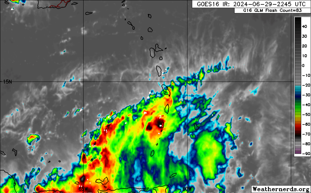
A tropical wave will continue to affect mainly the southern half of the Lesser Antilles during the next 24 hours.
BERYL IS NOW A HURRICANE AND FORECAST TO INTENSIFY QUICKLY..
At 5:00 pm today, the center of Hurricane Beryl was located near latitude 10.1 degrees north, longitude 49.3 degrees west or about 834 miles or 1343 kilometres southeast of Saint Lucia. Beryl is moving toward the west near 22 mph or 35 km/h. A relatively quick westward to west-northwestward motion is expected during the next few days. On the forecast track, the system is expected to move across the Windward Islands late Sunday night and Monday.
Maximum sustained winds have increased to near 75 mph or 120 km/h, with higher gusts. Rapid strengthening is forecast, and Beryl is expected to become a dangerous major hurricane before it reaches the Windward Islands. Hazardous swells generated by the system are expected to reach the Windward and southern Leeward Islands by late Sunday.
A Hurricane warning is in effect for Barbados. A Hurricane Watch is in effect for Saint Lucia, St. Vincent and the Grenadines and Grenada. A Tropical Storm Watch is in effect for Martinique, Dominica and Tobago.
Another tropical wave located over the eastern Tropical Atlantic is moving westward near 15 mph or 24 km/h. This wave has a high chance of development over the next seven (7) days, and a tropical depression could form by the middle of next week.
Interests in the Windward and southern Leeward Islands are advised to closely monitor the progress of these systems and take the necessary precautions.