Present weather at Hewanorra Airport is cloudy with showers. Present weather at GFL Charles Airport is cloudy. Present temperature at Hewanorra Airport is 25°C or 77°F. Last night’s minimum temperature at Hewanorra Airport was 25°C or 77°F. Relative humidity at Hewanorra Airport is 94%. Wind at Hewanorra Airport is blowing from the east at 21 mph or 33 km/h. Rainfall in the 24-hour period that ended at 2:00 am today: At Hewanorra Airport: 11.5 mm. Total rainfall for the month of June thus far: At Hewanorra Airport: 123.1 mm.
Sunset today: 6:36 pm. Sunrise tomorrow: 5:39 am.
FORECAST FOR SAINT LUCIA VALID FOR THE NEXT 24 HOURS Winds will be blowing from the northeast to east-southeast near 40 mph or 65 km/h, near hurricane strength with higher gusts. Weather: Cloudy to overcast with moderate to heavy showers, periods of rain, thunderstorms and strong gusty winds.
Residents and motorists in areas prone to flooding and landslides are advised to exercise extreme caution from tonight. All persons are advised to take all necessary precautions against the hazards associated with severe weather conditions.
MARINE FORECAST FOR SEAS IN A 25 MILE OR 40 KM RADIUS FROM SAINT LUCIA Tides for Castries Harbour: Low at 6:18 am…High at 1:07 pm. Tides for Vieux Fort Bay: Low at 7:45 am…High at 2:14 pm. Seas: Very rough with waves and swells 13 to 20 feet or 4.0 to 6.1 metres, from this morning. Residents are advised to stay away from the beaches and coastlines. Small craft operators are advised to remain in port and secure all vessels and equipment.
FORECAST FOR THE LESSER ANTILLES Cloudy to overcast with gusty winds, thunderstorms, scattered moderate to heavy showers and periods of rain.
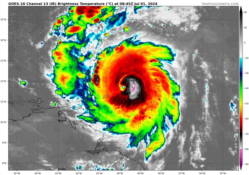
TROPICAL WEATHER OUTLOOK BERYL TAKING AIM AT THE WINDWARD ISLANDS… LIFE-THREATENING WINDS AND STORM SURGE TO BEGIN THIS MORNING. At 5:00 am today, the center of Hurricane Beryl was located near latitude 11.7 North, longitude 59.9 West or about 175 miles or 282 Kilometres southeast of Saint Lucia. Beryl is moving quickly toward the west near 20 mph (31 km/h). A quick westward to west-northwestward motion is expected during the next few days. On the forecast track, the center of Beryl is expected to move across the Windward Islands this morning and across the southeastern and central Caribbean Sea late today through Tuesday. Maximum sustained winds are near 120 mph (195 km/h), with higher gusts. A Hurricane Warning is in effect for Barbados, Saint Lucia, St. Vincent and the Grenadines and Grenada and Tobago. A Tropical Storm Warning is in effect for Martinique and Trinidad. A Tropical Storm Watch is in effect for Dominica.
A tropical wave located over the central Tropical Atlantic is moving westward near 21 mph or 33 km/h. This wave has a high chance of development over the next seven (7) days, and a tropical depression could form by the middle of next week. Interests in the Windward and southern Leeward Islands are strongly advised to closely monitor the progress of these systems and take all the necessary precautions.
For the latest advisory on Hurricane Beryl, please visit www.slumet.gov.lc.