
Center of Tropical Storm Bret approaching St Vincent and St Lucia
By NHC
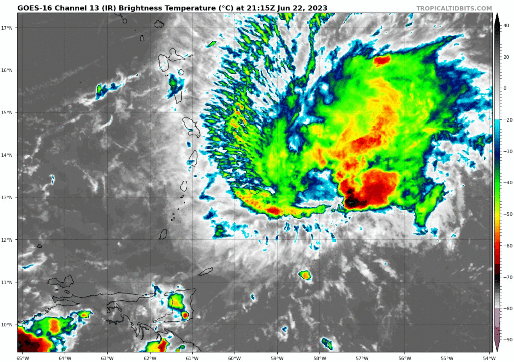
Tropical Storm Bret Intermediate Advisory Number 14A
NWS National Hurricane Center Miami FL AL032023
800 PM AST Thu Jun 22 2023
…CENTER OF BRET APPROACHING ST. VINCENT AND ST. LUCIA…
…HEAVY RAIN AND STRONG WINDS EXPECTED IN PORTIONS OF THE LESSER
ANTILLES THROUGH TONIGHT…
SUMMARY OF 800 PM AST…0000 UTC…INFORMATION
LOCATION…13.4N 60.3W
ABOUT 55 MI…90 KM SE OF ST. LUCIA
ABOUT 60 MI…95 KM WNW OF BARBADOS
MAXIMUM SUSTAINED WINDS…65 MPH…100 KM/H
PRESENT MOVEMENT…W OR 265 DEGREES AT 16 MPH…26 KM/H
MINIMUM CENTRAL PRESSURE…1004 MB…29.65 INCHES
WATCHES AND WARNINGS
CHANGES WITH THIS ADVISORY:
None.
SUMMARY OF WATCHES AND WARNINGS IN EFFECT:
A Hurricane Watch is in effect for…
St. Lucia
A Tropical Storm Warning in in effect for…
Dominica
St. Lucia
Martinique
Barbados
St. Vincent and the Grenadines
A Hurricane Watch means that hurricane conditions are possible
within the watch area, in this case within the next 24 hours.
A Tropical Storm Warning means that tropical storm conditions are expected somewhere within the warning area, in this case within 24
hours.
Interests elsewhere in the Lesser Antilles should monitor the
progress of Bret. Additional watches or warnings may be required
later tonight.
For storm information specific to your area, please monitor
products issued by your national meteorological service.
DISCUSSION AND OUTLOOK
Maximum sustained winds are near 65 mph (100 km/h) with higher
gusts. Gradual weakening is anticipated over the next couple of
days, and the system is likely to dissipate over the central
Caribbean Sea on Sunday.
At 800 PM AST (0000 UTC), the center of Tropical Storm Bret was
located near latitude 13.4 North, longitude 60.3 West. Bret is
moving toward the west near 16 mph (26 km/h) and this general motion with an increase in forward speed is expected during the next few days. On the forecast track, the center of Bret is expected to move across the Windward Islands during the next several hours, and then
move westward across the eastern and central Caribbean Sea Friday and Saturday.
Tropical-storm-force winds extend outward up to 115 miles (185 km)
from the center. Several automated stations on Martinique have
recently reported sustained winds of 40-45 mph (65-70 km/h) and
wind gusts of 50-60 mph (85-95 km/h).
The estimated minimum central pressure is 1004 mb (29.65 inches).
HAZARDS AFFECTING LAND
Key messages for Bret can be found in the Tropical Cyclone
Discussion under AWIPS header MIATCDAT3, WMO header WTNT43 KNHC and on the web at hurricanes.gov/text/MIATCDAT3.shtml
WIND: Hurricane conditions are possible in the hurricane watch area this evening or tonight. Tropical storm conditions are expected within the tropical storm warning areas through tonight.
RAINFALL: Storm total rainfall amounts of 3 to 6 inches with
maximum amounts of 10 inches are possible across portions of the
Lesser Antilles from Guadeloupe south to St Vincent and the
Grenadines, including Barbados. The heavy rainfall could lead to
flash flooding, especially across areas of higher terrain. Urban
flooding is also possible.
SURF: Swells generated by Bret are expected to affect portions of
the Lesser Antilles through Friday. These swells are likely to
cause life-threatening surf and rip current conditions. Please
consult products from your local weather office.
NEXT ADVISORY
Next complete advisory at 1100 PM AST.