
Tropical Storm Franklin forms in the Caribbean Sea
By SLUMET
Forecaster: Maclean Jn Baptiste
Present weather at Hewanorra Airport is cloudy.
Present weather at GFL Charles Airport is overcast.
Present temperature at Hewanorra Airport is 28°C or 82°F.
Today’s maximum temperature at Hewanorra Airport was 28°C or 82°F.
Wind at Hewanorra Airport is blowing from the east at 12 mph or 19 km/h.
Rainfall in the 24-hour period that ended at 2:00 pm today:
At Hewanorra Airport: 55.2 mm. At GFL Charles Airport: 70.8 mm.
Total rainfall for the month of August so far:
At Hewanorra Airport: 139.3 mm. At GFL Charles Airport: 144.6 mm.
Sunrise tomorrow: 5:51 am Sunset tomorrow: 6:22 pm
FORECAST FOR SAINT LUCIA VALID FOR THE NEXT 24 HOURS
Winds will be blowing from between the east-northeast and east near 14 mph or 22 km/h.
Weather: Partly cloudy to cloudy at times with some scattered showers and a slight chance of isolated thunderstorms.
MARINE FORECAST FOR SEAS IN A 25 MILE OR 40 KM RADIUS FROM SAINT LUCIA
Tides for Castries Harbour: High at present…Low at 12:11 am…High: at 6:33 am.
Tides for Vieux Fort Bay: High at 7:14 pm…Low at 01:38 am…High at 7:40 am.
Seas: Moderate with waves and northeasterly to easterly swells 4 to 6 feet or 1.2 to 1.8 metres.
FORECAST FOR THE LESSER ANTILLES
Generally cloudy skies with scattered light to moderate showers and a chance of isolated thunderstorms over the Leeward Islands. Further south, Partly cloudy to cloudy at times with some scattered showers and a slight chance of isolated thunderstorms.
TROPICAL WEATHER OUTLOOK
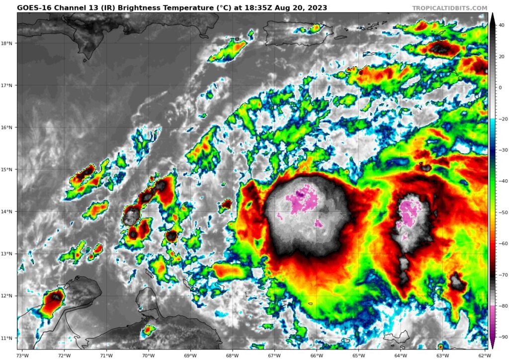
Tropical Storm Franklin forms in the Caribbean Sea…
At 5:00 pm today, the center of Tropical Storm Franklin was located near latitude 14.6 North, Longitude 67.1 West. Franklin is moving toward the west-northwest near 14 mph or 22 km/h. Maximum sustained winds are near 45 mph or 75 km/h, with higher gusts. Some strengthening is forecast during the next 48 hours. Moisture and instability trailing Tropical Storm Franklin will continue to affect portions of the Lesser Antilles tonight.
Tropical Depression Six is expected to become a remnant low and dissipate by tomorrow…
At 5:00 pm today, the centre of Tropical Depression Six was located near latitude 16.6 North, longitude 54.7 West or about 565 miles or 910 kilometres east of the northern Leeward Islands. The depression is moving toward the west-northwest near 9 mph or 15 km/h.
Tropical Storm Emily expected to weaken during the next couple of days…
At 5:00 pm today, the centre of Tropical Storm Emily was located near latitude 20.2 North, longitude 39.4 West. Emily is moving toward the northwest near 9 mph or 15 km/h and a west-northwest motion is expected during the next couple of days. Maximum sustained winds are near 50 mph or 85 km/h, with higher gusts. Gradual weakening is forecast and Emily could become a post-tropical cyclone in a couple of days. Tropical Storm Emily does not pose any direct threat to the Lesser Antilles.
Another tropical wave located over the far eastern Tropical Atlantic is moving westward near 15 mph or 24 km/h. This system has a low chance of tropical cyclone formation during the next 48 hours.