
A hurricane watch has been issued for Barbados and additional watches and warnings will likely be required for Saint Lucia and portions of the Windward Islands later today
Forecaster: Webster Gajadhar
Present weather at Hewanorra Airport is cloudy and hazy.
Present temperature at Hewanorra Airport is 27°C or 81°F.
Last night’s minimum temperature at Hewanorra Airport was 26°C or 79°F.
Relative humidity at Hewanorra Airport is 89%.
Wind at Hewanorra Airport is blowing from the east at 16 mph or 26 km/h.
Rainfall in the 24-hour period that ended at 2:00 am today:
At Hewanorra Airport: 1.6 mm.
Total rainfall for the month of June thus far:
At Hewanorra Airport: 95.4 mm.
Sunset today: 6:35 pm. Sunrise tomorrow: 5:39 am.
FORECAST FOR SAINT LUCIA VALID FOR THE NEXT 24 HOURS
Winds will be blowing from the east near 20 mph or 31 km/h.
Weather: Partly cloudy, becoming cloudy at times, with scattered showers and a chance of isolated thunderstorms.
MARINE FORECAST FOR SEAS IN A 25 MILE OR 40 KM RADIUS FROM SAINT LUCIA
Tides for Castries Harbour: High at 10:08 am…Low at 3:28 pm.
Tides for Vieux Fort Bay: High at 11:15 am…Low at 4:55 pm.
Seas: Moderate with waves 4 to 6 feet or 1.2 to 1.8 metres.
FORECAST FOR THE LESSER ANTILLES
Partly cloudy to cloudy, with scattered light to moderate showers and isolated thunderstorms over the central Windward Islands and areas further south. Elsewhere, fair to occasionally cloudy, with widely scattered showers.
TROPICAL WEATHER OUTLOOK
A tropical wave will continue to affect mainly the southern half of the Lesser Antilles during the next 24 hours.
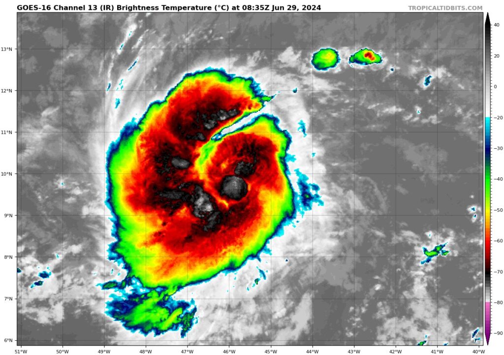
Tropical Depression Two has been upgraded to a tropical storm.
At 5:00 am today, the center of Tropical Storm Beryl was located near latitude 9.8 degrees north, longitude 45.5 degrees west or about 1086 miles or 1748 kilometres east-southeast of Saint Lucia. Beryl is moving toward the west near 21 mph or 33 km/h. A relatively quick westward to west-northwestward motion is expected during the next few days. On the forecast track, the system is expected to move across the Windward Islands late Sunday night and Monday.
Maximum sustained winds have increased to near 50 mph or 85 km/h, with higher gusts. Additional steady to rapid strengthening is expected during the next couple of days, and Beryl is expected to become a hurricane tonight or Sunday. Hazardous swells generated by the system are expected to reach the Windward and southern Leeward Islands by late Sunday.
A hurricane watch has been issued for Barbados and additional watches and warnings will likely be required for Saint Lucia and portions of the Windward Islands later today.
Another tropical wave located over the eastern Tropical Atlantic is moving westward near 12 mph or 19 km/h. This wave has a medium chance of development, and a tropical depression could form by the middle of next week.
Interests in the Windward and southern Leeward Islands are advised to closely monitor the progress of these systems and take the necessary precautions.