August 28th 2022
Four disturbances are moving through the Atlantic. Here’s what forecasters are saying

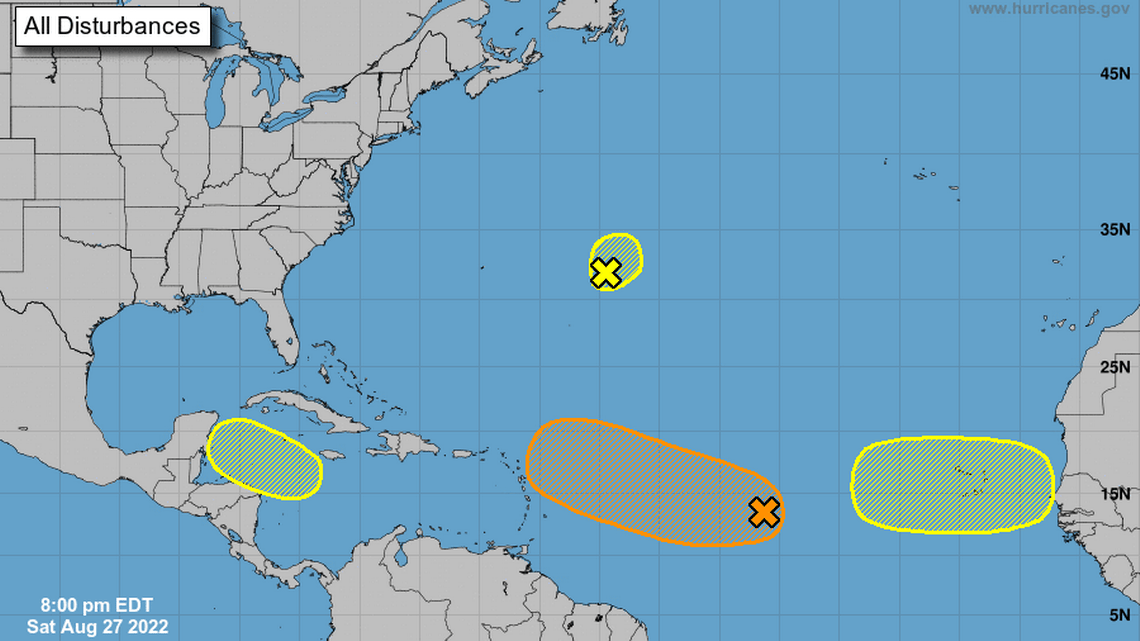
There are now four disturbances traversing the Caribbean Sea and Atlantic Ocean, some may see development in the coming days, forecasters say.
The first is an elongated area of low pressure over the central tropical Atlantic Ocean, moving west-northwestward at 10 to 15 mph, the National Hurricane Center’s 8 p.m. advisory said.
It has become a little better organized since Friday and forecasters believe environmental conditions are favorable enough for it to see some more gradual development over the next several days.
A tropical depression could form by the middle of next week. It has a 20% chance of forming in the next two days and a 50% chance through the next five days.
The next disturbance is a small low pressure area about 600 miles east of Bermuda, forecasters say. It could see some slow development in the next two to three days as it meanders over the central Atlantic.
It has a 10% chance of forming in the next two days and a 20% chance through the next five days. In the northwestern Caribbean Sea a trough of low pressure is developing.
Conditions could help the system see some slow development while it moves west-northwestward over the Caribbean Sea and toward the Yucatan Peninsula of Mexico, forecasters say.
It has no chance of forming in the next two days and a 20% chance through the next five days. The last disturbance is a tropical wave forecast to move off the west coast of Africa early next week.
It could see some gradual development during the middle of next week while it moves west across the far eastern Tropical Atlantic.
It has no chance of forming in the next two days and a 20% chance through the next five days.

TO RECEIVE NEWS NOTIFICATIONS VIA WHATS APP PLEASE SAVE OUR NUMBER AND SEND US A MESSAGE AT 7584896261 AND WE WILL ADD YOU TO OUR LIST


