
30th June 2021
Tropical Depression forms, Tropical storm watch changed to warning
By National Hurricane Center
[DISPLAY_ULTIMATE_SOCIAL_ICONS]
BULLETIN
Tropical Depression Five Advisory Number 2
NWS National Hurricane Center Miami FL AL052021
1100 PM AST Wed Jun 30 2021
...TROPICAL DEPRESSION FORMS OVER THE TROPICAL ATLANTIC...
...EXPECTED TO BECOME A TROPICAL STORM EARLY THURSDAY...
SUMMARY OF 1100 PM AST...0300 UTC...INFORMATION
-----------------------------------------------
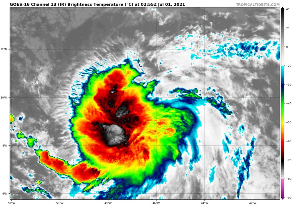
LOCATION...9.6N 46.3W
ABOUT 1020 MI...1645 KM ESE OF THE WINDWARD ISLANDS
MAXIMUM SUSTAINED WINDS...35 MPH...55 KM/H
PRESENT MOVEMENT...W OR 280 DEGREES AT 23 MPH...37 KM/H
MINIMUM CENTRAL PRESSURE...1008 MB...29.77 INCHES
WATCHES AND WARNINGS
--------------------
CHANGES WITH THIS ADVISORY:
The government of Barbados has issued a Tropical Storm Warning for
Barbados.
The government of France has issued a Tropical Storm Warning for
Martinique.
The government of St. Lucia has issued a Tropical Storm Warning for
St. Lucia.
SUMMARY OF WATCHES AND WARNINGS IN EFFECT:
A Tropical Storm Warning is in effect for...
* Barbados
* Martinique
* St. Lucia
A Tropical Storm Watch is in effect for...
* St. Vincent and the Grenadines
* Guadeloupe
A Tropical Storm Warning means that tropical storm conditions are
expected somewhere within the warning area within 36 hours.
A Tropical Storm Watch means that tropical storm conditions are
possible within the watch area, generally within 48 hours.
Interests elsewhere in the Windward Islands, Leeward Islands, the
Virgin Islands, Puerto Rico, the Dominican Republic, and Haiti
should monitor the progress of this system. Warnings and
additional watches will likely be required tonight and on Thursday.
For storm information specific to your area, please monitor
products issued by your national meteorological service.
DISCUSSION AND OUTLOOK
----------------------
At 1100 PM AST (0300 UTC), the center of Tropical Depression Five
was located near latitude 9.6 North, longitude 46.3 West. The
depression is moving toward the west near 23 mph (37 km/h). An even
faster motion to the west-northwest is expected over the next 24 to
36 hours. On the forecast track, the system will pass near or over
portions of the Windward Islands or the southern Leeward Islands on
Friday, move into the eastern Caribbean Sea late Friday and Friday
night, and move near the southern coast of Hispaniola on Saturday.
Maximum sustained winds are near 35 mph (55 km/h) with higher gusts.
Strengthening is forecast and the tropical depression is expected to
become a tropical storm early Thursday.
The estimated minimum central pressure is 1008 mb (29.77 inches).
HAZARDS AFFECTING LAND
----------------------
Key messages for Potential Tropical Cyclone Five can be found in
the Tropical Cyclone Discussion under AWIPS header MIATCDAT5, WMO
header WTNT45 KNHC and on the web at
www.hurricanes.gov/graphics_at5.shtml?key_messages.
WIND: Tropical-storm conditions are expected in portions of the
Windward and southern Leeward Islands within the warning area
beginning late Thursday night into Friday. Tropical storm
conditions are possible in the watch area beginning late Thursday
night into Friday.
RAINFALL: The system will produce rainfall totals of 3 to 6 inches
with maximum totals of 8 inches on Friday across the Windward and
southern Leeward Islands, including Barbados. This rain may produce
isolated flash flooding and mudslides.
NEXT ADVISORY
-------------
Next intermediate advisory at 200 AM AST.
Next complete advisory at 500 AM AST.
$$
Forecaster Papin/Brown

TO RECEIVE NEWS NOTIFICATIONS And Covid NEWS VIA WHATS APP PLEASE SAVE OUR NUMBER AND SEND US A MESSAGE AT 7584896261 AND WE WILL ADD YOU TO OUR LIST
[DISPLAY_ULTIMATE_SOCIAL_ICONS]


